Réunion
Méthodes d'apprentissage pour la navigation et le pistage
Axes scientifiques :
- Fusion, multimodalité , réseaux de capteurs, traitement multicanal
Organisateurs :
- - Audrey Giremus (IMS Bordeaux)
- - Gael Pages (ISAE - SCANR)
Nous vous rappelons que, afin de garantir l'accès de tous les inscrits aux salles de réunion, l'inscription aux réunions est gratuite mais obligatoire.
Inscriptions
18 personnes membres du GdR IASIS, et 32 personnes non membres du GdR, sont inscrits à cette réunion.
Capacité de la salle : 50 personnes. 0 Places restantes
Inscriptions closes pour cette journée
Annonce
L’intelligence artificielle (IA), et plus particulièrement l’apprentissage profond, occupe une place croissante dans notre quotidien et se retrouve dans un très grand nombre d’applications, aussi bien grand public que critiques. Avec l’émergence des modes de transport autonomes, elle est appelée à jouer un rôle important. Il est donc primordial de définir les contours des algorithmes de navigation et de pistage futurs, incluant les méthodes d’apprentissage, afin d’aller vers des approches plus précises mais également plus sûres.
Cette journée d’échange, organisée avec le soutien de l’ISAE-SUPAÉRO, invite les acteurs académiques et industriels à réfléchir sur les enjeux et les défis de l’utilisation de l’IA au sein des systèmes de navigation et de pistage. Les méthodologies visant à améliorer l’interprétabilité et l’explicabilité des modèles issus de l’apprentissage automatique seront au coeur des discussions lors de cet événement. Une attention particulière sera accordée aux travaux de recherche explorant l’hybridation des techniques d’apprentissage profond avec des modèles physiques ou des modèles de connaissances, pour gagner en compréhension et en fiabilité.
D’un point de vue pratique, le repas du midi et les pauses café seront pris en charge.
Orateurs invités :
- Silvère Bonnabel (Mines Paris)
- Sébastien Trilles (Thales Alenia Space)
Appel à contributions
Nous lançons également un appel à contribution : les personnes souhaitant présenter leurs travaux sont invitées à soumettre leur proposition (titre et résumé étendu de 2 pages maximum) aux deux organisateurs de la journée. Date limite : le 13 Juin.
Lieu : Amphi 2 – ISAE-SUPAÉRO – 10 avenue Marc Pélegrin – Toulouse – France.
Organisateurs :
- Audrey Giremus (Université de Bordeaux) : audrey.giremus@u-bordeaux.fr
- Gael Pages (ISAE-SUPAERO) : gael.pages@isae-supaero.fr
Inscription : sur la page de la journée. Nous vous rappelons que, afin de garantir l’accès de tous les inscrits aux salles de réunion, l’inscription aux réunions est gratuite mais obligatoire. Date limite pour prise en charge de la mission : le 23 Juin.
Programme
9h : accueil
9h30 : introduction
9h40 : exposé invité de Silvère Bonnabel (Mines Paris), "Enhancing the Extended Kalman filter with machine learning and backpropagation".
10h30 : "AI-aided Kalman filters, a review from the navigation perspective" par Léa Dubreil (ISAE-Supaéro - TéSA).
11h - 11h30 : pause café
11h30 - 12h : "Intelligence artificielle pour la navigation aérienne : stratégies d'apprentissage pour la localisation de piste d'atterrissage et quantification d'incertitude" par Solène Vilfroy (Thales AVS, laboratoire IMS, laboratoire Xlim).
12h - 13h30 : pause repas (restaurant universitaire de l'ISAE-Supaéro)
13h30 - 14h20 : exposé invité de Sébastien Trilles (Thales Alenia Space), "Quelle place pour l’IA dans les systèmes de Navigation ?"
14h20 - 14h50 : "Wasserstein distance based semi-supervised manifold learning for GNSS multipath detection" par Antoine Blais (ENAC).
14h50 - 16h10 : pause
16h10 - 16h40 : "Enhancing TDCP-based Integrity Monitoring with AI for Soft Mobility Users" par Ziyou Li (précédemment doctorant à l'Université Gustave Eiffel de Nantes, maintenant ingénieur de recherche Nav4you).
16h40 - 17h10 : "Enhancing Jamming Resilience in GNSS-based Localization for Safety-Critical Land Transportation : Towards an Optimized Mitigation Approach Focusing User-Requirements" par Syed Ali Kazim (précédemment doctorant à l'Université Gustave Eiffel de Lille, maintenant ingénieur de recherche Railenium).
Résumés des contributions
Présentation de Silvère Bonnabel
The Kalman filter (KF) and its nonlinear extension (EKF) are a cornerstone in estimating the state of a dynamical system from noisy measurements, crucial for many real-world applications. However, the accuracy of those filters, hinge on precise tuning of various parameters. The sensitivity equations, developed by Gupta and Mehra in 1974 for maximum likelihood parameter estimation, allow for computation of the effect of small variations in these parameters on the KF estimates and its internal variables. By leveraging the gradient backpropagation method, a key technique in neural networks, we introduce a much more numerically efficient method to analytically compute these derivatives for the KF and the EKF.
We will illustrate the potential of these novel sensitivity equations through several applications. First, adaptive filtering for navigation, where an EKF is combined with a neural network, that dynamically adapts its noise parameters at all times, and allows for localization of a car over hours using only inertial measurements. Then, active sensing, where gradients of the EKF’s covariance matrix with respect to the control inputs allow for computation of navigation trajectories that optimize the information gathered by sensors, demonstrated with real experiments.
Main references
Brossard, M., Barrau, A., & Bonnabel, S. (2020). AI-IMU dead-reckoning. IEEE Transactions on Intelligent Vehicles.
Parellier, C., Barrau, A., & Bonnabel, S. (2023). Speeding-up backpropagation of gradients through the kalman filter via closed-form expressions. IEEE Transactions on Automatic Control.
Présentation de Léa Dubreil
Navigation and tracking have been relying on Bayesian estimation. Principally Kalman Filters (KF) and its variants have been adopted as the state-of-the-art methods in the field and for valid reasons. In essence, they offer a known and tractable state space representation under perfect knowledge of the system's dynamics. Proof of their optimal performances have been demonstrated by Durbin and Koopman (2012) and they adapt from measurements.
However, critical systems face technical challenges, the essence of Kalman Filters is rarely found when working with real data. The stochastic models at the root of Kalman Filtering are partially known. Data driven techniques advantages offers in some extend a counterbalance of Kalman Filtering techniques However, they bring their own cons: computational and training complexity, lack of explainability even interpretability. Moreover, they predict without providing a quantification of uncertainty of their measure, whereas one can expect that from Kalman based techniques. The challenging implementation of machine learning has opened the field of an hybridisation between state estimation and machine learning techniques. The assumption is to bring the advantages of both techniques and balance out. Shlezinger et al. (2024) review the first architectures of what is defined to become AI-aided Kalman Filters through two major learning paradigms: discriminative and generative learning. We propose to add a depth of study into the work of Shlezinger et al. 2025 and to show an updated view on its usage inside critical systems such as navigation systems. Two major properties were selected to perform the study: the adaptiveness and the interpretability of the methods. In fact, we found that these characteristics are found to be essential to navigation and tracking systems, often used in critical systems facing outliers, changing dynamics and environments.
References
Durbin and Koopman (2012), Time series analysis by state space methods, Oxford University Press
Shlezinger et al. (2024), AI aided Kalman Filters, arXiv.
Présentation de Solène Vilfroy
Les véhicules autonomes sont de plus en plus présents dans notre société, notamment grâce aux avancées en intelligence artificielle. Toutefois, dans le domaine de la navigation aérienne, certains défis persistent, en particulier lors des manœuvres d’atterrissage. Dans nos travaux, nous nous sommes intéressés à la localisation de la piste d’atterrissage à partir de cartes radar 4D (distance, azimut, élévation, Doppler) acquises durant le segment final d’approche, l’une des phases les plus critiques de l’atterrissage. En explorant et en comparant différentes stratégies d’apprentissage, nous avons conçu une architecture de réseau de neurones intégrant des mécanismes d’attention, exploitant les connaissances sur les structures attendues afin d’optimiser l’identification des éléments caractéristiques de la scène d’approche. Ce travail a abouti à un modèle contenant un faible nombre de paramètres et compatible avec des applications embarquées.
La seconde partie de nos travaux s’est concentrée sur la quantification de l’incertitude, un enjeu majeur dans un secteur aussi strictement réglementé que l’aviation. Pour évaluer l’intégrité du modèle, nous nous sommes intéressés aux prédictions conformes. Elles permettent de fournir des garanties statistiques sur l’estimation de la déviation angulaire, en définissant un intervalle de confiance autour de la prédiction du modèle. Dans ce contexte, nous avons apporté plusieurs contributions : d’une part, une stratégie visant à minimiser la largeur moyenne des intervalles de confiance; d’autre part, l’intégration de données contextuelles, telles que l’angle de roulis de l’avion, afin de garantir des performances constantes quelle que soit la valeur de cette métadonnée.
Présentation de Ziyou Li
With the growing popularity of location-based wearable devices, the need for ubiquitous and reliable positioning for soft-mobility users has become crucial. It is particularly benefit for vulnerable pedestrians, such as visually impaired
people whose daily movements are safety-critical. To achieve an accurate and reliable positioning solution, Integrity Monitoring (IM), can be utilized to identify and exclude faulty measurements, while also estimating the uncertainty of the positioning solution and alerting the user if this uncertainty becomes intolerably large. Originally developed for aviation and later extended for vehicular applications, IM is still rarely used for pedestrian users. Also, most human activities take place in urban and indoor environments where the multipath and NLOS (Non-Line-Of-Sight) dominate the GNSS signal propagation channel. This presents significant challenges for the traditional statistical-based IM approaches. Therefore, the objective of this research work is to design novel IM algorithms to meet the requirements of accurate and reliable positioning for pedestrian users. Artificial Intelligence (AI) is ideally suitable for developing new IM algorithms, due to its capabilities in classification (identifying faulty measurements) and regression (estimating uncertainty). In this research, a novel AI-based IM system is proposed, which aims at providing a reliable positioning solution for pedestrian users in stringent environments. The GNSS carrier phase measurements, which is proven more robust against noise compared to the code measurement, is deployed with the Time Difference Carrier Phase (TDCP) positioning algorithm. With TDCP as the baseline, firstly a machine learning (ML)-based healthy GNSS carrier phase selection algorithm is developed. This algorithm, called Light Indoor GNSS macHine-learning-based Time difference carrier phase (LIGHT), is designed for selecting useful carrier phase measurements in challenging environments (light indoors, deep urban) to enhance positioning accuracy.
Secondly, a Long Short-Term Memory (LSTM)-based uncertainty estimator is proposed to estimate the Protection Level (PL). The integrity specification is innovatively integrated into the loss function, to make sure the estimated PL tightly overbounds the error while meeting the integrity requirement. The proposed AI-based IM system can be efficiently hybridized with a Pedestrian Dead Reckoning (PDR) solution, calculated from inertial and magnetic signals, to further improve positioning accuracy. Also, the effectiveness of the proposed system is proven in different soft mobility transportation modes.
Présentation de Sébastien Trilles
Fin 2022 le prédicteur de texte et assistant conversationnel de la société OpenAI bouleversa le monde des IA génératives. Depuis, les techniques d’IA ne cessent de se perfectionner et s’invitent désormais dans pratiquement tous les domaines. Les systèmes de Navigation par satellites n’échappent pas à cet attrait. S’il est indéniable que les technologies à base d’IA apportent des résultats spectaculaires dans certaines applications spécifiques, offrant ainsi des gains de productivités importants, peut-on dire la même chose concernant le domaine de la Navigation pour laquelle la Physique, au travers des lois qu’elle énonce, verrouille beaucoup les phénomènes contributifs de la performance de ces systèmes ? Que peut donc apporter l’IA dans la science de la Navigation ? Cet exposé se propose de planter le décor et d’envisager, sans prétendre à l’exhaustivité, les cas d’usages où les contributions de l’IA seraient significatives.
Présentation d'Antoine Blais
One of the main weaknesses of the Global Navigation Satellite Systems (GNSSs) is the sensitivity to multi-path disturbances. A multi-path is a reflection of the signal emitted by a navigation satellite on one or more surfaces surrounding the receiving antenna. These multi-paths degrade the precision and accuracy of the position calculated by the GNSS receiver. This could lead to potential hazard especially in safety of life applications. Aircraft navigation which heavily depends on GNSS nowadays is a typical illustration. Thus, detecting the possible distortion in the input data is of prior importance. Previous studies [1] have shown the interest of supervised Machine Learning (ML) techniques in the purpose of detecting distortion in GNSS signals. However, real labelled data are scarce. This is a genuine difficulty as supervised ML algorithms require in general large amount of labelled data for training.
The aim of this research work is to consider semi-supervised learning as a mean to train a ML model with less labelled data while maintaining the same detection performance in comparison to an equivalent fully supervised ML model or to improve the detection performance with unlabelled data in addition to the same amount of labelled data.
The data of interest in this study are produced by the RF front-end of a GNSS receiver. More precisely, the signal available at the output of the RF front-end comes in two orthogonal channels. It is then shaped into two two-dimensional matrices or equivalently a pair of images [2]. The components of the pair are noted I and Q by convention in the GNSS community. Each pair of images is a snapshot of the received signal at a given time, a mix of the signal of interest, of the receiver noise and of any other disturbing interference captured by the antenna. This image representation has proven to be efficient when coupled to a Convolutional Neural Network (CNN) to detect a multi-path signal affecting the Line-Of-Sight (LOS) signal [1]. It has also been demonstrated that the same association was effective to estimate the parameters of the multi-path signal [2]. The CNN implemented in the publications mentioned above need large amount of labelled data to be trained. However, real labelled data are scarce or expensive in the GNSS field. Then, a synthetic data generator has been used to create training and testing data sets.
In this study, the synthetic data generator is still used but the purpose is to show that it is possible to reduce the dependency to the generator by using semi-supervised learning [3]. The underlying principle is that the manifold of the data can also be learned by the network through unlabelled samples if a suitable measure of similarity with labelled samples is provided. The metric chosen in this study to compare images is the Wasserstein distance also known as the Earth Mover’s Distance (EMD). This distance can be regarded as the minimum effort needed to transform the first image into the second one when each pixel value is considered as a mass.
The implementation of the unsupervised contribution to the training process takes the form of a regularisation term in addition to the classical supervised Binary Cross Entropy (BCE) loss function. This unsupervised term is linear in image thus it preserves the ability to process large data sets by batches of data and it benefits from stochastic gradient based techniques during training too. This research work being still in progress the assessment of the method is not complete at the time of this writing. However, some preliminary results will be proposed during the presentation.
References
[1] A. Blais, N. Couellan, and E. Munin, “A novel image representation of GNSS correlation for deep learning multipath detection,” Array, vol. 14, p.100167, 2022. [Online]. Available: https://www.sciencedirect.com/science/article/pii/S2590005622000297
[2] T. Gonzàlez, A. Blais, N. Couëllan, and C. Ruiz, “Distributional loss for convolutional neural network regression and application to parameter estimation in satellite navigation signals, ”Expert Systems with Applications, vol. 255, p. 124682, 2024. [Online]. Available: https://www.sciencedirect.com/science/article/pii/S0957417424015495
[3] J. Weston, F. Ratle, H. Mobahi and R. Collobert, Deep Learning via Semi-supervised Embedding. Berlin, Heidelberg: Springer Berlin Heidelberg, 2012, pp. 639–655. [Online]. Available: https://doi.org/10.1007/978-3-642-35289-8_343
Présentation de Syed Ali Kazim : Enhancing Jamming Resilience in GNSS-based Localization for Safety-Critical Land Transportation : Towards an Optimized Mitigation Approach Focusing User-Requirements.
-
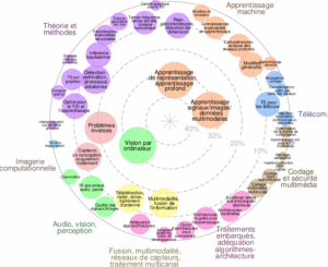

![]() Expertises du GdR - cartographie par Axes - 19/09/2025
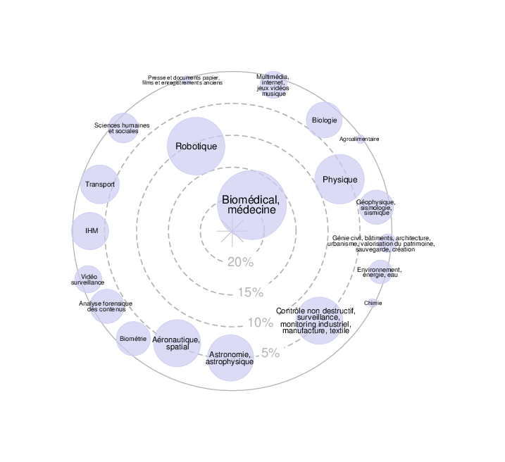
Expertises du GdR - cartographie par Axes - 19/09/2025![]() Expertises du GdR - cartographie par mots-clés applicatifs - 19/09/2025
Expertises du GdR - cartographie par mots-clés applicatifs - 19/09/2025